Trail system expansion starting soon
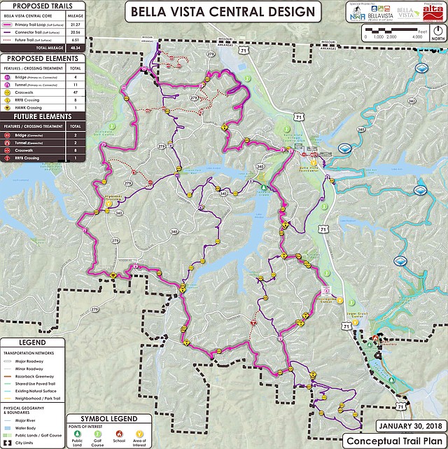
Image provided by NWA Trailblazers A conceptual map of what the central section of Bella Vista's trails could look like. Erin Rushing, executive director of NWA Trailblazers, said that paths may have to change during construction to work around large buried rocks and other obstacles.
Wednesday, September 5, 2018
Another trail system is coming to Bella Vista potentially doubling the city's trail mileage.
City council approved a lease agreement with the POA during its August regular meeting, and the Walton Family Foundation issued a $3.9 million grant to fund the construction of the trails and the first two years' maintenance.
A groundbreaking ceremony will be at Lake Avalon Beach at 2 p.m. Friday, Sept. 14, with an informal gathering to follow at BV Bar and Grill.
Mayor Peter Christie said this network will be interconnected with both the Back 40 trails and, once the Mercy Way Bridge project is concluded, the Razorback Greenway.
"The riders and the hikers will have 100 miles," he said.
City communications manager Cassi Lapp pointed out that Bella Vista comes out ahead of nearly any community in terms of trail volume.
"No other city has 100 miles. No other city has 50 miles," she said.
At this point, it is impossible to know what additional trail maintenance costs will look like until the trails have been maintained for a while, she said, but the city is looking into more efficient ways to keep the trails maintained.
Vegetation management is the hardest part, she said, and the city might not be able to keep it under control if so many trail users didn't put in volunteer work.
Christie explained that these trails are emblematic of growth and changing demographics in the city and in preparation for more of it.
The younger residents moving to the area tend to enjoy different activities -- spending time on the lake, biking and trail running, for example -- and having these options makes Bella Vista more attractive and fits with making the city a strong recreational community, he said.
"It goes way back to the changing demographics. We have a lot of younger folks," he said. "We do really have to make sure we're managing the growth."
Moreover, he said, these amenities bring people into the city and attract events, which can help the city show there is a demand for more commercial development. That, he said, translates to more tax revenue to build roads and fund the city's emergency services.
"Very excited about it," he said.
Erin Rushing with NWA Trailblazers, a nonprofit that works to build trails in the area, said construction could start as early as mid-September and workers may be out flagging routes this week.
Rushing said this trail network should be between 40 and 50 miles, but it's impossible to say what the exact length will be until the network is complete because the proposed layout and what's feasible to build may be different from one another. The proposed trail will stretch north to the Missouri state line and south to the Bentonville Border.
Once routes are flagged, he said, workers can bring in equipment to begin cutting trails. He estimated building the entire network could take between 12 and 14 months. The two trail-building firms contracted for the project are Rogue Trails and Rock Solid Contracting.
The Back 40 trails were started in January and opened in October, but Rushing said this network will be a significantly more complex project, in part because the central portion of town on the west side of the interstate is laid out differently.
"It's much more challenging," he said.
The two biggest challenges, he explained, are topography and property boundaries. Avoiding the steeper hills and keeping the trail on common property or property purchased specifically for the trails can be tricky -- especially when trying to find the scenic route.
"We're trying to find these natural features, these rock outcroppings and these waterfalls, what makes Bella Vista cool," he said.
Moreover, he said, Arkansas Highways 340 and 279 present another major obstacle. While the Back 40 trails cross several streets, he said, these streets do not have any straight, visible sections that would be especially safe for a crossing.
The solution is to go under them, he said, which will make these trails unlike any other.
"Tunnels are the most iconic feature," he said.
Another highlight will be a bridge crossing Little Sugar Creek, just south of Arkansas Highway 340, to access a spur that will connect to the Back 40, he said.
And new to this system will be a green rated (or beginner) trail section in the southeastern corner. The current plan calls for a roughly 5-mile loop of beginner-friendly trail, he explained.
Planning started with a master trail plan the city adopted in 2015, which included a trail network for the eastern and central portions of town as well as the Highlands, he said. More in-depth planning started in January 2017 and took roughly a year and a half.
One thing that's absent from the plan, he said, is a name. Several have been tossed around but nothing has really stuck.
"We've got a list of 50," Rushing said. "It's all over the place."
General News on 09/05/2018