Bella Vista Planning and Code Enforcement director Chris Suneson has spoken at length about the city's need to update its Future Land Use Plan and Mayor Peter Christie agrees with him.
But before city officials can address the plan, which functions as a citywide zoning manifesto, Bella Vista must establish its planning area boundaries.
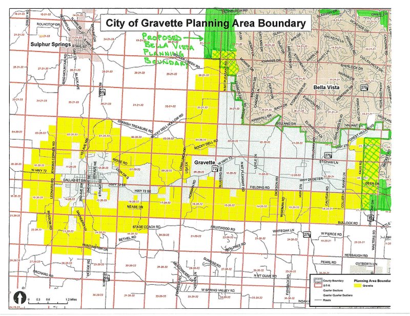
Planning boundaries establish and define parameters for what a city controls in regard to its development. Bella Vista adopted a planning area boundary in 2007, which laid claim over areas in the south and west that were part of the Interstate 49 corridor.
However after several annexations by Gravette and Bella Vista, the planning areas shifted while the boundaries went unchanged.
The commission on Jan. 12 approved the same resolution. However, commission votes are not binding, and serve only as a recommendation to the council.
"Before you can do anything else you've got to establish your planning boundaries," said Jennifer Bonner, Bella Vista Planner I. "That will limit your scope of work for when you go to change other items."
Plus, now that Bella Vista is incorporated, city officials would like to create the planning boundaries "in house," Bonner said.
Since the city had no staff in 2007, Northwest Arkansas Regional Planning created the boundaries. At the time, regional planning was using land incorporated from Bella Vista Village, which belonged to Cooper Communities Inc. and the Property Owners Association.
"There was sort of a boundary for that, and they went off of that set," Bonner said. "But as the city limits changed over time, that's when things really got messed up."
The issue was further complicated in 2012, when Gravette annexed land to the southwest in the Hiwasse area. Gravette adopted a new planning boundary plan and failed to take into account how it affected Bella Vista's jurisdiction, Bonner said.
"What we're trying to do is find a happy medium, so we're not going all the way to their city lines and they're not going all the way to our city lines," Bonner said. "We're picking some of that empty space in between but (also) follows parcel lines in between so we're not taking somebody's property in more than we have to and splitting it between (Gravette) and us."
Mike Vonrees, who works in Gravette's Planning and Code Department, said Monday that only a small change is needed to adjust the map. He said he expects the Gravette City Council will address the item at its regular meeting later this month.
Suneson said he has "every faith" that Gravette and Bella Vista will come to an agreement.
"We're trying to resolve it so that we get to an agreed line," Suneson said. "But if we want to firm this up, let's do it once rather than twice. (Mayor Christie) has indicated to me that he wants us to revise the (Future Land Use Plan), and this is the first step in that process."
General News on 02/11/2015